iMOD – Groundwater modelling
Groundwater accounts for approximately 99% of our freshwater reserves and provides a significant quantity of our daily water supplies. So understanding where it is and in what quantities and quality is of growing importance. Modellers need to be able to simulate their groundwater systems, and predict the impact of future climate change and management interventions. iMOD Suite is the software toolbox for creating very large, high resolution and fast groundwater models in the industry standard MODFLOW 6. IMOD Suite enables specialists to provide reliable, evidence-based advice to decision makers on the most sustainable way to manage their groundwater resources.
Development of iMOD started in 2006. Since 2021 two software products are available: iMOD 5 and iMOD Suite. Both products are freely available and open-source.
iMOD 5, the classic version of iMOD, supports structured calculations with MODFLOW2005 and structured MODFLOW 6 and iMOD Water Quality. It can be coupled to the unsaturated zone model MetaSWAP. IMOD 5 is a fast and dedicated graphical user interface for model building and results analysis. iMOD 5 will be maintained for the foreseeable future.
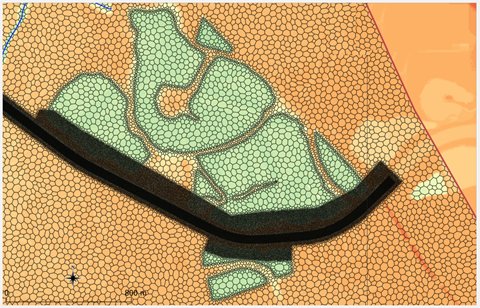
iMOD Suite is the latest product development with a focus on supporting unstructured grids for MODFLOW 6. The IMOD Suite consists of a Python package for building large complex groundwater models, not only for MODFLOW 6 but also MODFLOW2005 and iMOD Water Quality. Part of iMOD Suite is an iMOD plugin for visualizing data in QGIS, for example, bore logs, cross sections and time series.
IMOD has the ability to build large complex groundwater models, from which nested sub-domain models can be extracted for specific detailed studies. It is a step forward leaving behind the era of building a series of individual, often inconsistent, local models.

Features of iMOD
- iMOD is a free and open-source groundwater modelling software.
- Uses the well-known and proven MODFLOW computational code.
- Supports structured and unstructured grids.
- Flow model nesting, toggling between grid resolutions and moving to new areas of interest.
- Consistency between regional and sub-domain models.
- Interactive 2D- and 3D-analysis and visualisation.
- Interactive editing the geometry of the subsurface.
- Easy integration with other models via the iMOD Coupler.
How to obtain iMOD
IMOD is open-source free to use. The latest fully validated release can be downloaded via our Download Portal. You can order a Service package via our Sales Service team: software@deltares.nl.
If iMOD is free, why should I get a service package? For users where iMOD is part of a critical workflow we recommend a service package where users receive support from Deltares during Netherlands office hours. If you already have an older iMOD model and want it updated to the latest version then get in touch with us.
For technical questions about the software please contact: imod.support@deltares.nl

